Help with Terrains, Relief Maps, and Grayscale Images
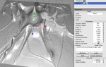
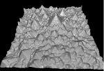
I am struggling to understand how to turn a grayscale image into a terrain. My ultimate goal is to render a surface that has been imaged with scanning tunneling microscope. The path that I envision is:
Take data --> Convert to grayscale (format?) --> Load into Cheetah3D --> Render
At the moment, I am having difficulty turning the default relief map into my imaged data. A different post suggested "choose Terrain->Import Heightmap - Raw..., then select the desired RAW file;" however, I have been unable to find the "Terrain" menu item.
If it makes a difference, I am using the demo copy of Cheetah3D. I own a much earlier version and will be happy to upgrade as soon as I verify Cheetah3D's suitability for this application.
Many thanks,
Melissa